Richmond’s urban fabric is inseparable from its geotechnical reality. Built almost entirely on the Fraser River delta, this island city has wrestled with soft, compressible soils since its early farming days. The transformation from bog and floodplain into a dense residential and commercial hub—home to over 200,000 people and anchored by the Vancouver International Airport—required extensive diking and ground improvement. Any slope stability analysis in Richmond BC must account for the interbedded silts, peats, and loose sands that define the subsurface. Excavations near the Middle Arm or along Highway 99 reveal how quickly a cut face can degrade when pore pressures rise. The technical team brings direct experience with these deltaic sequences, applying a slope stability analysis that integrates pore pressure monitoring and staged construction sequencing to match the NBCC and Fraser Basin Council guidelines. When trenching through the city’s characteristic organic layers, we often combine the analysis with a test pit investigation to ground-truth stratigraphy before modeling the factor of safety.
Richmond’s peat layers can reduce the factor of safety by half if pore pressures are not properly drained before cutting.
Methodology applied in Richmond BC
Critical ground factors in Richmond BC
The most common error on Richmond sites is proceeding with a cut without accounting for the delayed pore pressure response in silt and peat. Contractors accustomed to granular soils elsewhere in Metro Vancouver will open a trench, see it stand vertically for a few hours, and assume the geometry is safe. Then the tide rises, or a rainstorm hits, and the face slumps overnight. A proper slope stability analysis models these transient conditions explicitly—steady-state seepage, rapid drawdown on the river side, and consolidation-driven strength changes in the organic layers. Ignoring the time-dependent behavior means a design that looks acceptable on paper fails in the field. In a city where the water table sits barely a meter below ground surface across much of the Lulu Island footprint, the analysis must treat groundwater as the primary destabilizing agent, not an afterthought.
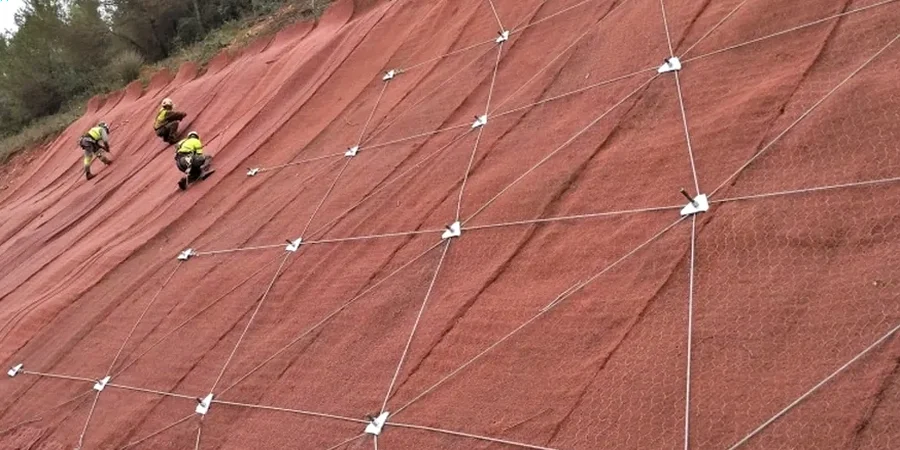
Our services
The scope of work adapts to Richmond’s infrastructure demands, from riverbank stabilization to deep basement retention in the City Centre area.
Dike and Riverbank Stability Assessment
Evaluations along the Fraser River dike network accounting for rapid drawdown conditions, tidal fluctuations, and the soft organic soils that underlie Richmond’s perimeter flood protection. Modeling follows provincial dike management guidelines with limit equilibrium and finite element methods.
Excavation and Cut Slope Analysis
Stability checks for temporary and permanent cuts in Richmond’s layered deltaic deposits. The analysis incorporates groundwater control measures and staged excavation effects, critical for deep utility trenches and below-grade parking structures in the Capstan Village and Oval Village precincts.
Frequently asked questions
What is the approximate cost range for a slope stability analysis in Richmond?
The fee typically ranges from CA$1,620 to CA$5,830 depending on the slope height, the number of cross-sections modeled, and whether instrumentation data like piezometer records are included. A simple cut analysis falls at the lower end, while a full riverbank stability assessment with seismic loading and multiple stratigraphic sections falls at the higher end.
Which soil parameters matter most for Richmond’s deltaic deposits?
The effective friction angle of the silts and the undrained shear strength of the peat are the two most critical inputs. Richmond’s Fort Langley silts often show φ’ values between 28° and 33°, but the peat layers can have Su values below 15 kPa, which dominate the failure surface location.
Do Richmond projects require seismic slope stability analysis?
Yes. Under NBCC 2020, Richmond is classified as Site Class D or E due to its soft soil profile, which amplifies seismic shaking. A pseudostatic analysis with a horizontal coefficient appropriate for the site class is standard, and for critical infrastructure a post-earthquake deformation analysis using Newmark’s method is often required by the provincial dike safety guidelines.